Tuesday, May 16, 2023

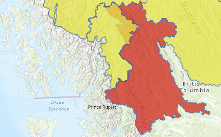
River Forecast Centre upgrades Skeena, Bulkley Rivers and tributaries to FLOOD WARNING status.

UPDATE: Regional District of of Kitimat-Stikine has issued a number of evacuation orders  

See their FloodWatch website page here

The City of Terrace has also issue advisories for residents, that information is available here.

Further Inland, The Regional District of Bulkley Nechako has advice for the Town of Smithers, Village of Telkwa and other communities.  


******************************* Original Story **********************************

The snow melt is increasing with the current heat wave and as it does the level of Northwest rivers is rising as well, with the River Forecast Centre upgrading yesterday's Flood Watch to a FLOOD WARNING.

The latest advisory from the River Forecast Centre issued this morning notes of accelerated path to flood status:

Hot temperatures are leading to accelerated snowmelt in the region. Streamflow in most areas has begun to rise in response to increased snowmelt runoff. With hot temperatures expected to persist through next week, on-going rises in river levels is expected. 
Current monitoring is indicating most gauged rivers in the region are flowing at 2-year to 10-year flows. 

On the Bulkley River near Smithers (Water Survey of Canada Gauge 08EE005), flows are expected to exceed the flood stage (>5.0m) today and may reach up to 10-year flow levels (5.4m) over the Wednesday-Thursday period (May 17-18) 

On the Skeena River at Usk (08EF001) water levels have reached 10.8m and are anticipated to exceed flood stage (11.0m) later today. Flows are forecast to continue to rise over the next few days (May 17-19) and may reach up to 20-year flows (7000 m3/s or 12.5-13.0 m)

The full advisory can be accessed here, by clicking the red area of the map.

Any potential impact that flooding may have on Highway 16 between Terrace and Prince Rupert can be found through updates on the Drive BC website.

See our archive page for updated news from the Flood warning regions.

More notes on past weather events can be explored here.

No comments:

Post a Comment