 |
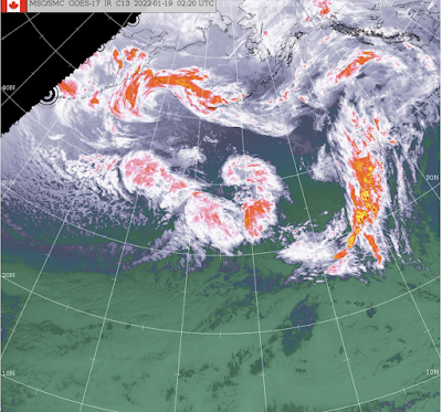
| Satellite imagery from Environment Canada shows the scope of the approaching weather system set to arrive overnight |
Wednesday is shaping up to be a pretty wet affair for the Prince Rupert area as a weather system just offshore makes its way inland overnight, with up to 75 mm of precipitation to come for coastal areas, bringing with it a warming trend for the rest of the week.
Temperatures will rise overnight to a high of 7 on Wednesday once at that level, the thermometer will hover between 6 and 7 through the rest of the week and into the weekend.
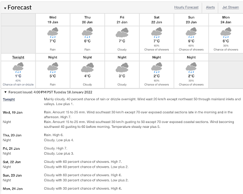 |
| Click to enlarge |

Haida Gwaii will get the first hit of the system, though it won't be as strong as that reaching the coast, with winds and 20mm of rain expected overnight.
For the Marine Forecast, a STORM WARNING has been issued, with winds of 40 knots and seas building to 4 metres by Wednesday afternoon.
Inland things will be significantly different, with a WINTER WEATHER WARNING already I place for the Terrace area and points North once again, as well as along the western highway 16 corridor.
Anticipated snow amounts are listed at up to 20 centimetres along with freezing rain for Terrace, 25 centimetres for the Nass Valley and 30 centimetres further north near Stewart.
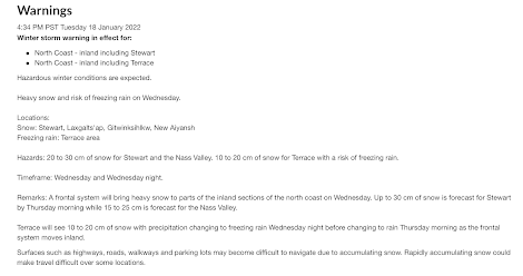 |
| click to enlarge |
Follow the Environment Canada Website for updates for both Terrace and Prince Rupert overnight and through Wednesday.
If travelling on the highways tomorrow, follow the Drive BC website and twitter feed for the latest notes on road conditions.
As well, you can explore the range of highway cameras in the Northwest to see what the conditions are along the routes of the region.
A look at some of the recent weather events of the past can be reviewed from our archive.
No comments:
Post a Comment